


")


NEW DELHI: The southwest monsoon finally reached Delhi on Thursday, five days after its normal date of onset on June 27, India Meteorological Department (IMD) officials said.It made a modest start, with Safdarjung, the city’s base weather station, recording 4.6 mm of overnight rainfall. Several other parts of the capital received light to very light overnight showers during the night. Aya Nagar got 5 mm, Ridge 3 mm and Pusa 1.9 mm. Some localities recorded heavier rainfall, with Tukmirpur in northeast Delhi logging 20 mm and Chhatarpur 18.5 mm.

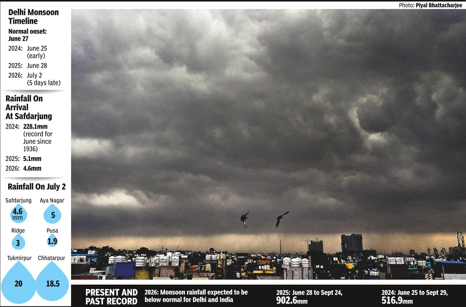
The arrival of the monsoon improved Delhi’s air quality and lowered its temperature. The maximum at Safdarjung was 33 degrees Celsius, 4.4 notches below normal. IMD issued a yellow alert for rain and thunderstorms Friday. The maximum may hover between 30 and 32 degrees Celsius.The city is expected to record a below-normal monsoon this year. Nationally, the cumulative rainfall remains at a 33.5% deficit so far. This deficit may reduce due to good rains in the next week or so as monsoon advances further into the country.On June 29, the northern limit of monsoon extended through parts of Madhya Pradesh and Bihar, senior IMD scientist Krishna Mishra said. By the next day, it advanced into Uttar Pradesh and covered most parts of Uttarakhand and Ladakh. On July 1, it spread across Jammu & Kashmir and Himachal Pradesh before covering the rest of UP, most of Punjab and Haryana, parts of Rajasthan and finally Delhi on July 2.With this, monsoon has now covered entire UP, MP and parts of Rajasthan and Gujarat. Conditions remain favourable for its further foray into the rest of Rajasthan, Gujarat and Punjab and Haryana over the next two to three days.Explaining its quick advance across northwest India, Mishra said that an interaction between a western disturbance in the middle tropospheric levels and strong monsoon easterlies in the lower troposphere in the past two days accelerated its progress.IMD said a low-pressure area over northwest Bay of Bengal adjoining the north Odisha-West Bengal coast is expected to keep monsoon active over central India during the next five days. Isolated extremely heavy rain-fall is likely over south Gujarat, Konkan, Saurashtra, Kutch, west MP, Odisha and parts of Maharashtra.Monsoon’s arrival in the national capital this year is later than in recent years. In 2025, it reached Delhi on June 28 and remained active until Sept 24, during which the city received 902.6 mm of rainfall, 40.9% above its long-period average rainfall.The 2024 monsoon arrived unusually early in Delhi on June 25, bringing a remarkable 228 mm of rainfall on the very first day – the highest single-day rainfall in the month of June in the city since 1936. The season eventually ended with 516.9 mm before monsoon withdrew on Sept 29.This year, monsoon reached Kerala on June 4, three days later than its normal onset date of June 1. Last year, it arrived remarkably early on May 24 and went on to cover the entire country by July 2, its fastest nationwide advance in five years.


